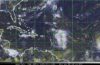
BRIDGETOWN, Barbados, Aug 23 2016 – A tropical wave located about 750 miles east of the Lesser Antilles is producing disorganized shower and thunderstorm activity. Based on this, the Miami based National Hurricane Centre has advised interests in the Eastern Caribbean to monitor the progress of this system.
The National Hurricane Centre says while dry air is expected to slow development during the next few days, environmental conditions could become more conducive for development late this week when the system is expected to move near Hispaniola and the southeastern and central Bahamas.
An Air Force Reserve Hurricane Hunter aircraft is scheduled to investigate the system on Tuesday.
The system has a 50 percent chance of developing into a tropical cyclone during the next five days.
Meanwhile, a low pressure area associated with a tropical wave was centered about 300 miles southwest of the southern Cabo Verde Islands.
The associated showers and thunderstorms are well organized.
Recent microwave satellite data suggests the system has not yet developed a well-defined circulation.
A tropical depression could form on Tuesday as the system moves westward to west-northwestward at 15 to 20 mph over the eastern tropical Atlantic Ocean.