Hurricane researchers at Colorado State University (CSU) are predicting an above-average Atlantic hurricane season in 2020, citing the likely absence of El Niño as a primary factor.
The researchers said tropical and subtropical Atlantic sea surface temperatures are currently warmer than their long-term average values and are consequently also considered a factor favouring an active 2020 Atlantic hurricane season.
“The tropical Pacific currently has warm neutral ENSO (El Niño-Southern Oscillation) conditions; that is, the waters are slightly warmer than normal in the eastern and central tropical Pacific,” said CSU in a statement.
“CSU currently anticipates that these waters are likely to cool relative to their long-term averages over the next several months,” it added. “Consequently, they do not anticipate El Niño for the peak of the Atlantic hurricane season.”
“El Niño ‘tends to increase upper-level westerly winds across the Caribbean into the tropical Atlantic, tearing apart hurricanes as they try to form,’” said CSU.
It said the tropical Atlantic is somewhat warmer than normal right now, stating that warmer-than-normal sea surface temperatures in the tropical Atlantic provide more fuel for tropical cyclone formation and intensification.
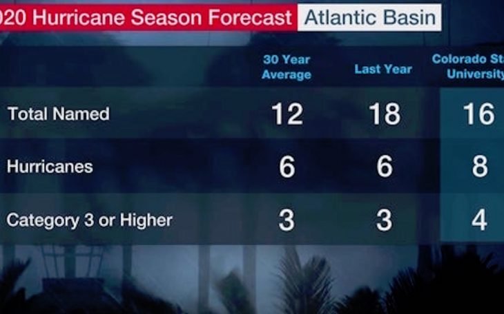
The institution’s Tropical Meteorology Project team is predicting 16 named storms during the Atlantic hurricane season, which runs from June 1 to November 30.
Of those, researchers expect eight to become hurricanes and four to reach major hurricane strength (Saffir/Simpson category 3-4-5) with sustained winds of 111 miles per hour or greater.
CSU said the team bases its forecasts on a statistical model, as well as two new models that use a combination of statistical information and forecasts from dynamical models from the United Kingdom Met Office and the European Centre for Medium-Range Weather Forecasts.
These models are built on 25-40 years of historical hurricane seasons and evaluate conditions including Atlantic sea surface temperatures, sea level pressures, vertical wind shear levels (the change in wind direction and speed with height in the atmosphere), El Niño (warming of waters in the central and eastern tropical Pacific), among other factors.
So far, it said the 2020 hurricane season is exhibiting characteristics similar to 1960, 1966, 1980, 1996 and 2008.
“1966, 1980, 1996 and 2008 had above-average Atlantic hurricane activity, while 1960 was a near-average hurricane season,” said Dr Phil Klotzbach, research scientist in CSU Department of Atmospheric Science and lead author of the report.
The team predicted that 2020 hurricane activity will be about 140 per cent of the average season. By comparison, 2019’s hurricane activity was about 120 per cent of the average season.
CSU said the 2019 season was most notable for Hurricane Dorian, which devastated the northwestern Bahamas, and for Tropical Storm Imelda, which caused tremendous flooding in portions of southeast Texas.
The CSU team will issue forecast updates on June 4, July 7 and August 6.
This is the 37th year that the CSU hurricane research team has issued an Atlantic basin seasonal hurricane forecast.