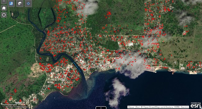
Powerful satellite technology can help Caribbean countries better manage natural disasters and boost climate resilience, as the region braces for a busy hurricane season.
A virtual event co-organised by the Commonwealth Secretariat and the UN Institute for Training and Research (UNITAR) showed how remote sensing satellite technology was recently used to support Asian and Pacific countries in responding to super cyclones Amphan and Harold.
These cutting-edge tools, provided by the UNITAR Operational Satellite Applications programme (UNOSAT), are even more vital as the Caribbean grapples with multiple threats linked to both climate disasters and the COVID-19 pandemic. Experts predict up to 10 hurricanes in the Atlantic by the end of the year.
Commonwealth Secretary-General Patricia Scotland said: “Responding effectively to these complex challenges of disease and disaster will rely more than ever on data that is accurate, reliable and timely, as well as country cooperation to share knowledge, experience and expertise.
“Our partnership with UNITAR and other key networks through the Commonsensing Project will help generate the data countries need to inform critical decision-making during times of crisis. It will also lead to more effective climate projects in the long-term and more robust applications for climate finance.”
UNITAR Executive Director, Nikhil Seth, added: “Satellite data and analyses are very powerful in providing hard evidence to back actions and policy decisions on disaster response and risk management. With Cyclones Harold and Amphan in the Asia Pacific for instance, UNITAR was able to generate data and analyses within 24 to 48 hours of the crises.
“Following analyses included the location and extent of damage to infrastructure and crops. We were also able to provide early and advanced information for crisis planning, such as mapping food security and predicting which areas would be hit the hardest by a disaster.”
Through the Commonsensing Project, the data will also help refine applications for climate finance from international donors. This builds on ongoing work by the Commonwealth Climate Finance Access Hub (CCFAH), which has, to date, raised US $33.6 million for 75 climate projects in Commonwealth small states. Additional funding of US $575 million has been applied for, pending approval.
The Commonsensing Project currently supports Fiji, Vanuatu and the Solomon Islands to strengthen capacity and bridge data gaps to improve access to climate finance, enhance climate policies and reduce the impact of climate-related disasters.
The project is funded through a £9.6 million grant from the UK Space Agency, supplemented by contributions from project partners, matched with in-kind contributions from the Governments of Fiji, Vanuatu and Solomon Islands. It is implemented by a consortium of international partners, led by the United Nations Institute for Training and Research (UNITAR), in collaboration with the Commonwealth Secretariat, the Satellite Applications Catapult, Devex International, the UK Met Office, Sensonomic, the University of Portsmouth and others.