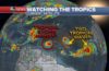
BRIDGETOWN, Barbados, Aug 18 2017 – Tropical Storm Harvey is beginning to bring rain to the Windward Islands, and may pose a threat early next week in parts of Central America’s Caribbean coast.
Tropical storm warnings have been issued for parts of the Windward Islands, including Martinique, St. Lucia, St. Vincent and the Grenadines. Warnings are issued when tropical storm conditions are expected within 36 hours. A tropical storm watch is in effect for Dominica, where those conditions are possible within that timeframe.
Tropical storm conditions, with winds of 39 mph or greater, are spreading through the warning area, making outside preparations difficult or dangerous.
Thunderstorm activity over the storm has not changed much since a Thursday afternoon hurricane hunter flight found winds of 40 mph. Another mission is currently taking place to see if anything has changed in the storm.
Harvey will bring 2 to 4 inches of rain across the Windward Islands from Martinique southward to Grenada, which could trigger life-threatening flash flooding and mudslides in mountainous terrain.
After that, the system will then track westward through the rest of the Caribbean Sea, and will likely pose a threat to parts of Central America and/or Mexico’s Yucatan Peninsula early next week.
It’s not clear how strong this tropical storm will become through its Caribbean trek, due to potential interaction with dry conditions and sinking air. Interests throughout the Caribbean should monitor the progress of Harvey through early next week.
At this time, Tropical Storm Harvey is not a threat to the United States.
Two Other Disturbances to Monitor
Invest 92L continues to fester a few hundred miles to the east of Harvey.
This invest has shown signs of strengthening and could become a tropical depression later today or over the weekend.
A fresh surge of such dry air, known as the Saharan Air Layer (SAL), is pushing toward 92L right now. This dry air may mix in with the disturbance, preventing thunderstorms from persisting and clustering.
Furthermore, if 92L tracks farther north, as expected, wind shear – the change in wind direction with height – is stronger to the north of the Leeward Islands, according to an analysis from the University of Wisconsin.
This hostile wind shear that typically rips apart tropical disturbances and weaker tropical cyclones may inhibit 92L from developing significantly, if it gains enough latitude north of the Leeward Islands this weekend.
A hurricane hunter mission has been tentatively scheduled for Saturday afternoon to determine if Invest 92L has organized and strengthened enough to be classified as a tropical depression or tropical storm.
It’s worth noting that even if 92L doesn’t develop into a tropical cyclone the next few days, this disturbance will likely continue migrating through the Bahamas, then into the Gulf of Mexico next week and will be monitored for any potential later development.
Finally, a tropical wave emerged off the west African coast Wednesday, well east of Harvey and 92L, kicking off its journey across the eastern Atlantic Ocean.
This latest wave may develop by the weekend but won’t near the longitude of the Lesser Antilles until early next week.
Like our Facebook page https://www.facebook.com/CaribbeanNewsService/
Follow us on Twitter https://twitter.com/CNewsService
Follow us on Instagram https://www.instagram.com/caribbeannewsservice/